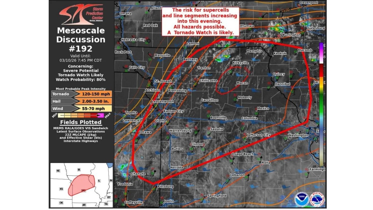
KANSAS CITY, MISSOURI — A rapidly intensifying severe weather system is taking shape across eastern Kansas and pushing into north and northwestern Missouri this afternoon. In response, the Storm Prediction Center issued Mesoscale Discussion #192 and signaled an 80% chance that officials will need to issue a Tornado Watch.
The alert zone runs from Topeka and Lawrence, Kansas, northeast through Kansas City, St. Joseph, and Leavenworth, and extends into Missouri communities including Chillicothe, Trenton, Kirksville, Macon, Hannibal, and Quincy.
Strong daytime heating is destabilizing the atmosphere across the warm sector, while a weak low-pressure system along the boundary is boosting lift and creating a stronger focus for storm development.
As upper-level energy approaches from the west:
- Winds strengthen with height
- Warm, unstable air continues to deepen
- Shear profiles become more favorable for rotating storms
This combination strongly supports supercell development.
Northern Missouri and Southern Iowa at Early Risk
Early storms moving along or just north of the boundary could still produce very large hail and damaging wind gusts across far northern Missouri and into southern Iowa, even before storms fully tap into surface-based instability.
Later this evening, storms are expected to become more surface-based within the warm sector, which will increase the tornado threat — including the potential for a few strong tornadoes.
Corridor of Concern: Central Kansas Into Missouri After 00Z
Guidance indicates that storms could initiate more fully within the next one to two hours. Additional development across central Kansas may move into Missouri after 00Z (7 PM CDT), allowing the severe threat to persist well into the evening.
Highlighted cities within the risk corridor include:
- Ottawa and Olathe, Kansas
- Kansas City metro
- Chillicothe and Carrollton, Missouri
- Kirksville and Macon
- Hannibal near the Mississippi River
The mesoscale discussion notes that a tornado watch will likely be issued if storm organization continues to strengthen.
Most Probable Severe Impacts
The discussion highlights potential peak intensities of:
- Tornadoes capable of producing 120–150 mph winds
- Hail measuring between 2.00 and 3.50 inches in diameter
- Wind gusts ranging from 55–70 mph
These values signal a setup capable of producing significant severe weather if storms develop as expected.
Evening Threat Window
The main uncertainty centers on timing — specifically when storms will fully organize and intensify. However, atmospheric trends favor storm development this afternoon into tonight, with the risk expanding eastward.
Residents across eastern Kansas and northern Missouri should stay weather-aware and be ready to act quickly if a Tornado Watch or warnings are issued.
ChicagoMusicGuide.com will continue tracking this developing severe weather situation across Kansas and Missouri as conditions evolve into the evening hours.


Leave a Comment