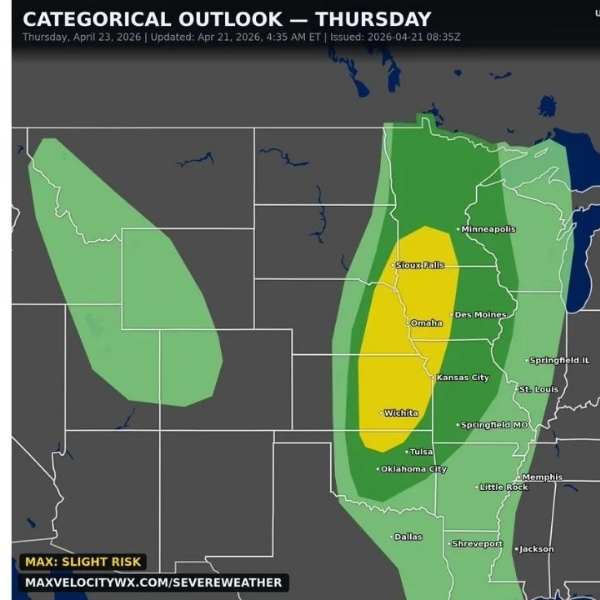
OMAHA, Neb. — A significant round of severe weather is expected Thursday, April 23, across parts of the Great Plains and Midwest, with damaging winds, very large hail and isolated tornadoes all possible.
Forecasters say the threat zone stretches from Oklahoma City through Wichita, Kansas City and Omaha, extending north toward Sioux Falls as a strong storm system moves into the region.
Thursday marks a shift from a brief calm period, with atmospheric conditions quickly becoming favorable for severe storms across multiple states.
Cities in the storm corridor
The risk area includes several major population centers:
- Nebraska: Omaha and Sioux Falls within the Slight Risk zone
- Kansas: Wichita in the core of the highest threat area
- Iowa: Des Moines along the eastern edge
- Missouri: Kansas City in a key convergence zone
- Oklahoma: Tulsa and Oklahoma City on the southern end
- Minnesota: Minneapolis on the northern fringe
Primary threats Thursday
Forecasters highlight three main hazards:
- Very large hail: Storms could produce hailstones the size of baseballs or larger, especially across Kansas and Nebraska
- Damaging winds: Gusts of 60 to 70+ mph are possible as storms organize into lines
- Tornadoes: Isolated tornadoes may develop, particularly with discrete supercell storms ahead of the main system
Different setup than recent outbreaks
Unlike recent severe weather events that focused heavily on tornadoes, Thursday’s system is expected to be driven more by hail and strong winds, with tornadoes as a secondary threat.
This means the risk may be more widespread, affecting a broader area rather than isolated tornado paths.
Large hail could cause significant damage to vehicles, roofs and windows in a short time, while strong winds may lead to power outages and hazardous travel conditions.
Active pattern continues
After Thursday’s storms move through, a quieter stretch is expected over the weekend. However, forecasters say the overall pattern remains active, with more storm chances possible as April ends and May begins.
What to watch
- Possible tornado watches Thursday afternoon
- Reports of large hail, especially in Kansas
- Wind damage in metro areas like Kansas City and Omaha
- Any upgrades in the storm risk level
Residents are urged to stay weather-aware and have a safety plan in place. Moving vehicles under cover and preparing for potential power outages can help reduce damage as storms develop quickly.


Leave a Comment