
HASTINGS, Neb. (KSNB) — After a morning with frost and areas of fog, conditions are expected to improve before another round of rain moves in later today. A few colder nights are also expected before the week ends.
Wednesday through Friday: Temperatures started near or below freezing for many areas, though frost cleared by mid-morning. Dense fog developed from west-central Nebraska into north-central Kansas, covering roughly the southwestern third of the region, but it will gradually clear as the sun returns.
By the afternoon, scattered showers and thunderstorms may develop over southwest Nebraska, with additional storms moving into northern Nebraska from South Dakota later in the day. These storms will spread southeast through the evening. Most rain will exit after midnight, leaving only a slight chance overnight. Severe weather is unlikely, though some storms could produce small hail and gusty winds. Highs will range from the upper 50s in the north to the mid-60s in the south. Overnight lows will be milder, ranging from the mid-30s northwest to the mid-40s southeast.
Thursday will bring cooler conditions with partly to mostly cloudy skies. Highs will range from the mid-50s north to the low to mid-60s south. Rain chances will be lower for most areas, with the best chances in far southern and southwestern locations. Skies will clear Thursday night, allowing frost to develop again as lows drop into the upper 20s and low to mid-30s.
Friday will feature more sunshine, with highs returning to the low to mid-60s. Clear skies Friday night will bring another cold night, with frost possible as temperatures fall into the upper 20s and low to mid-30s.
Saturday through Monday: Conditions will remain mostly quiet, with only slight chances for rain on Sunday and Monday. Warmer temperatures will move in, with highs ranging from the lower 70s in the east to the mid to upper 70s in the west. Sunday highs will range from the lower 70s north to the lower 80s south, while Monday will be slightly warmer, reaching the upper 70s north to the mid-80s south.
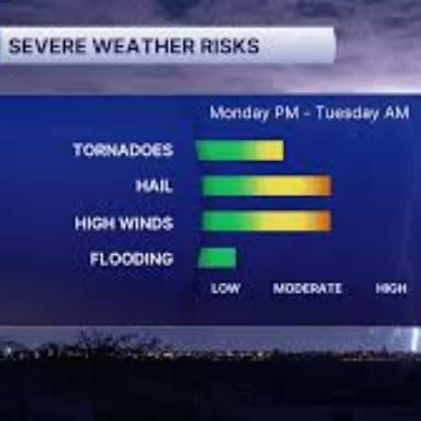
Tuesday and beyond: A cold front is expected to move south on Tuesday, bringing a better chance for rain late Tuesday into Tuesday night, possibly continuing into Wednesday. The highest chances appear to be in southern areas. Highs Tuesday will range from the mid-60s north to the upper 70s southeast. Cooler conditions will follow Wednesday and Thursday, with highs in the 50s and 60s, before temperatures begin to warm again toward the end of next week.


Leave a Comment