
A Severe Thunderstorm Watch is in effect until 7 p.m. for the Omaha metro and nearby areas, with scattered storms expected to bring potentially damaging conditions.
Storms this afternoon may produce hail between 1 to 2 inches in diameter. Residents are advised to stay alert for warnings and move away from windows as storms approach.
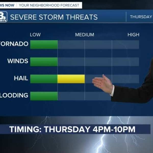
Additional storms could develop later in the day, with increasing confidence that some may turn severe. These storms could bring large hail and damaging winds, mainly between 2 p.m. and 9 p.m. across Omaha and into western Iowa.
More storm chances are expected Wednesday and again Friday afternoon.
Thursday will offer a break, with dry, sunny, and warm conditions returning. High temperatures are expected to reach the mid-80s.
Another round of storms is possible Friday as a cold front moves through the region, bringing a renewed risk of severe weather and strong winds. Temperatures will drop sharply from the 70s and 80s on Friday to the 30s by Saturday morning, with highs only reaching the 50s later in the day. Wind gusts could exceed 45 mph.
As winds calm Saturday night and skies clear, patchy frost and freezing conditions are expected, with Sunday morning temperatures dipping to around 29–32 degrees.
Conditions improve into Sunday and Monday, with dry, sunny weather and highs warming back into the 60s and 70s.
Wednesday Forecast
Partly sunny with scattered strong afternoon storms
High: 75
Wind: Southwest 15–25 mph
Wednesday Night
Storms ending, partly cloudy
Low: 50
Wind: Southwest 5–15 mph
Thursday
Partly sunny and warmer
High: 84
Wind: South 20–25 mph


Leave a Comment