The weekend looks dry and comfortable
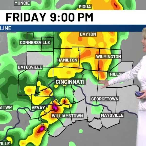
CINCINNATI (WXIX) – Expect a mild start to Friday, with morning temperatures in the 60s and afternoon highs climbing back into the low 80s. Winds will strengthen through the day, with gusts reaching 25 to 30 mph by the afternoon. Storm chances are arriving earlier than in recent days, with the main window now between 3 and 10 p.m. A MARGINAL Risk (1 out of 5) is in place, mainly for damaging winds. It won’t rain the entire time, but any storms that develop could disrupt evening plans, including Reds Fireworks Friday. Stay weather aware and keep an eye on the First Alert Weather App for alerts.
Showers and a few storms will continue into Friday night before conditions dry out early Saturday morning. The rest of the weekend looks excellent. Highs will settle into the low 70s with lower humidity and a mix of sun and clouds, creating great conditions for outdoor activities. Sunday looks even better, with comfortable temperatures and mostly sunny skies.
Attention shifts back to storm chances early next week. Monday begins quiet, but clouds will build with storms arriving later in the day. Storm activity will continue into Monday night, with the potential for severe weather. All hazards are possible at this point, so conditions will be closely monitored. Storms are expected to move out by Tuesday morning, followed by a breezy afternoon with some sunshine returning.
The middle of next week remains somewhat unsettled, with scattered storms possible on Wednesday and Thursday. Temperatures will trend cooler through the latter part of the week, leading to a noticeable cooldown by next weekend. As the Kentucky Derby approaches, highs are expected to drop into the 50s, a sharp contrast to the current 80-degree warmth.


Leave a Comment