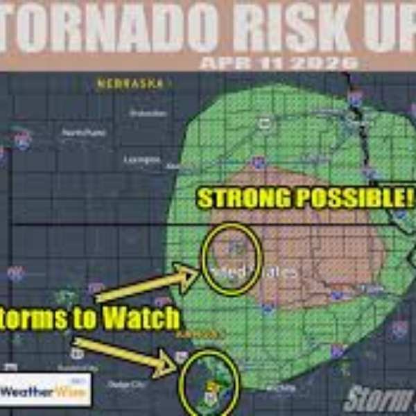
KANSAS CITY, Missouri — The Storm Prediction Center has upgraded its tornado outlook for Saturday, April 11, increasing tornado probabilities across a corridor from southeast Nebraska into northeast Kansas to a 5% hatched risk — a signal of growing forecaster confidence in a volatile, supercell-favorable environment capable of producing a few tornadoes, including a strong EF2 or greater event, during the key window from 3:00 PM to 10:00 PM CDT today.
The upgrade reflects rising confidence that storms will develop across the region, along with a more dangerous atmospheric setup forming along the warm front than earlier expected, according to the Storm Prediction Center (SPC/NOAA).
Cities and States in the Risk Zone
Nebraska: Grand Island, Lincoln, Omaha, Columbus, and North Platte are within the tornado risk zone — with Lincoln and Grand Island located inside the higher 5% hatched area where EF2+ potential is greatest
Kansas: Topeka, Salina, Emporia, Wichita, and much of northeast Kansas fall directly within the upgraded risk zone — Topeka and Salina lie in the core EF2+ potential area
Missouri: Kansas City, St. Joseph, and Jefferson City sit along the eastern edge of the broader tornado risk corridor
Iowa: Des Moines and parts of southern Iowa are included in the outer 2% tornado probability zone
Primary Threats
The SPC upgrade highlights several serious risks for residents across the region this afternoon and evening:
EF2+ strong tornado possible — The hatched zone from Grand Island to Lincoln to Topeka clearly indicates the potential for a significant tornado rated EF2 or stronger. This designation is not routine and is used only when forecasters have meaningful confidence in strong tornado development
Multiple tornadoes possible — If supercells persist along the warm front, a few tornadoes may occur between 3 PM and 10 PM CDT, suggesting a prolonged threat rather than a brief, isolated event
Volatile warm front environment — The upgrade is driven by increasing confidence in a more unstable environment along the warm front, where wind shear and moisture combine to support rotating supercells
Higher storm initiation confidence — Earlier uncertainty about storm development has decreased, with forecasters now more confident that storms will form, making the threat more immediate
Why This Matters for Nebraska and Kansas
A same-day SPC upgrade during an active severe weather setup is a strong signal that atmospheric conditions are becoming more dangerous, not less — and that preparation time is shrinking.
The 5% hatched tornado probability covering Grand Island, Lincoln, Salina, and Topeka is especially critical. The hatched designation — highlighted in forecasts as “EF2+ POSSIBLE!!” — indicates strong confidence in an environment capable of producing damaging tornadoes. An EF2 tornado brings winds of 111 to 135 mph, capable of destroying well-built homes, snapping large trees, and overturning vehicles. Stronger tornadoes can be even more destructive.
Residents in Lincoln, Grand Island, Topeka, and Salina are directly in today’s highest-risk corridor. The threat window begins at 3:00 PM CDT — a time that coincides with school dismissals, evening commutes, and outdoor activities. Those in the hatched area should be in a sturdy shelter and closely monitoring weather updates before this time.
Multi-Day Pattern
Saturday’s upgraded tornado threat marks the beginning of a multi-day severe weather pattern across the central United States. Sunday, April 12 brings another conditional severe weather setup across Texas, Oklahoma, and Kansas from San Antonio to Wichita. Monday, April 13 follows with a more organized severe weather threat across the broader Midwest. This is not a one-day event — communities across Nebraska, Kansas, and nearby states should remain alert through early next week.
What to Watch Next
The 3 PM CDT window marks the start of the danger period — be sheltered, weather-aware, and away from vehicles or mobile homes before this time if you are in the hatched zone
Residents in Grand Island, Lincoln, Omaha, Topeka, Salina, and Kansas City should use multiple methods to receive warnings, including weather radios, mobile alerts, and reliable weather apps
Tornado watches from the SPC are expected to be issued soon for parts of Nebraska and Kansas — a watch indicates favorable conditions, while a warning means a tornado has been detected and immediate shelter is required
The position of the warm front will influence where the strongest storms develop, with areas along and just north of the boundary facing the highest risk
Do not wait for a tornado warning to move to shelter if you are in the EF2+ hatched zone — response time may be very limited once warnings are issued
Monitor local National Weather Service offices, including NWS Omaha and NWS Topeka, for real-time updates and warnings
The Storm Prediction Center has made the situation clear — the tornado threat across southeast Nebraska and northeast Kansas is elevated, increasing, and time-sensitive. Residents in Grand Island, Lincoln, Topeka, Salina, and the Kansas City area should treat this as a serious threat, take shelter before 3 PM, and ensure multiple alert systems are active and ready.


Leave a Comment