Omaha came close to a record high on Tuesday, but temperatures will ease back from those summerlike levels over the next few days as storm chances increase heading into Thursday.
Warm and breezy Wednesday
Wednesday will remain warm and pleasant, with low humidity and afternoon wind gusts up to 25 mph. Overnight, south winds will strengthen, with gusts reaching up to 35 mph, while humidity gradually increases.
Storm chances build Thursday morning
As moisture moves north, a few showers and storms could develop Thursday morning along the Missouri River Valley. These may bring brief downpours during the morning commute before fading by midday.
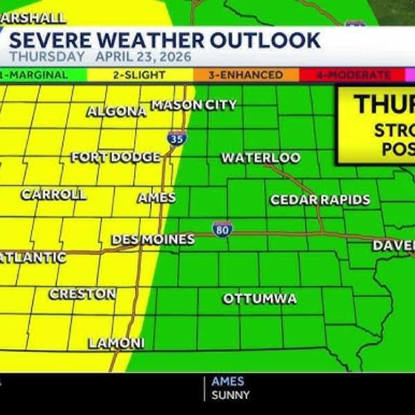
Severe storms possible Thursday afternoon and evening
A cold front is expected to move into the region Thursday afternoon, though the exact timing remains uncertain. Storms are likely to form across eastern Nebraska and organize into a line as they move into Iowa.
Early storms could produce large hail, strong winds and possibly an isolated tornado. As the system progresses, it is expected to transition into more of a wind and rain event later in the evening.
The storms could disrupt plans Thursday afternoon and evening, including school pick-ups, commutes and outdoor activities. Residents are encouraged to stay updated on forecasts and alerts.
Cooler weather and weekend outlook
Temperatures will trend cooler into the weekend, with highs in the 60s and possibly dipping into the 50s on days with more clouds or rain.
Looking ahead, Sunday carries the highest chance for rain, with scattered showers and thunderstorms likely throughout the day, which could make outdoor plans difficult.


Leave a Comment