UNITED STATES — A focused severe weather setup is expected to develop Thursday afternoon into the evening, with strong storms forecast from southeast Nebraska into northwest Missouri, including areas near Omaha and St. Joseph, where conditions may support isolated tornadoes.
Storms expected to develop late afternoon into evening
Forecast models indicate storms will begin forming later Thursday afternoon, with intensity increasing into the evening hours.
This timing means storms could rapidly strengthen during peak daytime heating, creating a window for more organized and potentially dangerous conditions.
Highest risk zone stretches from southeast Nebraska to St. Joseph, Missouri
The primary area of concern extends from southeast Nebraska down toward St. Joseph, Missouri. This corridor is expected to see the strongest storm development, with enough atmospheric energy to support severe weather.
Areas near Omaha sit along the northern edge of this risk zone but could still be affected depending on how the storms evolve.
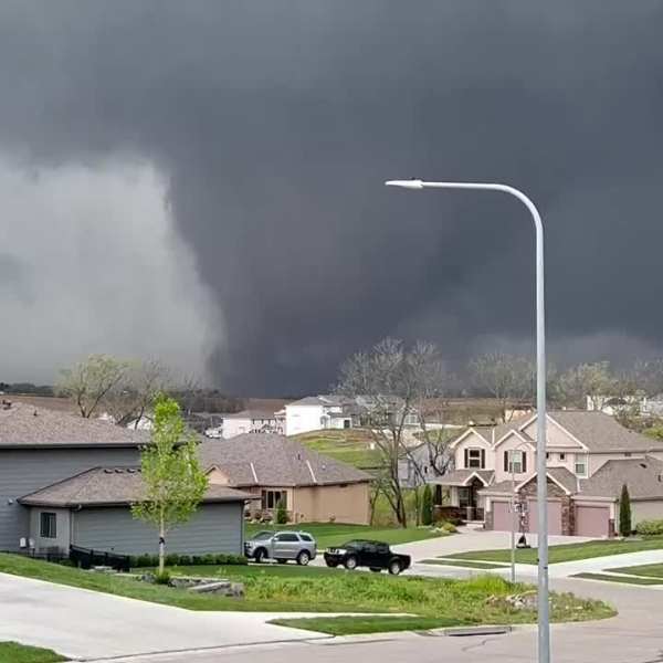
Tornado potential with stronger storm cells
Given the strength of the system, isolated tornadoes are possible, especially within the most intense storm cells. In addition to tornado risks, storms may also bring strong winds and localized heavy rainfall.
Early monitoring advised as system strengthens
Forecasters are highlighting this system earlier than usual due to its strength and potential impact. While details may still change, the current setup calls for close monitoring as Thursday approaches.
Residents across southeast Nebraska and northwest Missouri should stay alert for updates as storm timing and severity become clearer.


Leave a Comment