A warming trend returns midweek, bringing gusty winds, scattered storms, and additional rain chances through the weekend.
3 things to know
- Windy and warmer Wednesday
- More rain on Thursday
- Stormy conditions return this weekend
Forecast overview
Clouds will linger Tuesday evening with temperatures in the low 40s. Warmer air moving in overnight will push temperatures into the upper 40s and low 50s by Wednesday morning.
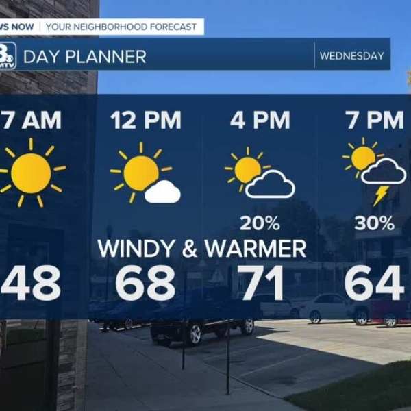
Wednesday begins sunny and noticeably warmer, with highs climbing to around 70 degrees by midday. Winds will strengthen in the afternoon, with gusts reaching up to 40 mph as a cold front moves in and stalls across southeast Nebraska overnight. A few isolated storms could develop near Falls City and into northwest Missouri.
As the front lingers south of Omaha, multiple rounds of showers and thunderstorms are possible on Thursday. While it won’t rain continuously, most areas could see precipitation at some point. Some storms near the stalled boundary may also produce small hail. Rain is expected to move out Thursday night, with Friday staying mostly dry.
Storm chances increase again over the weekend, with a few storms potentially becoming strong. Conditions will remain breezy, with highs in the 60s Saturday and rising into the 70s Sunday.
Rainfall totals through Sunday night are expected to range from about 0.50 to 1.00 inch.
Temperatures will stay above average into early next week, with highs in the 70s on Monday before cooler conditions return by midweek.
Detailed outlook
Tuesday Night
Mostly cloudy, warming
Low: 46
Wind: SE 10–25 mph
Wednesday
Partly cloudy, windy with afternoon storms
High: 71
Wind: SW 25–45 mph
Thursday
Cloudy with rain and storms
High: 59
Wind: E 5–10 mph


Leave a Comment