Mostly dry workweek
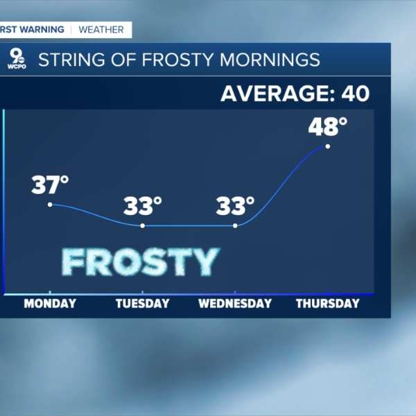
After a much cooler Easter, temperatures will drop further overnight under mostly clear skies. Lows will fall into the mid to upper 30s by Monday morning, cold enough for patchy frost, especially outside Cincinnati. Be sure to protect any sensitive plants before going to bed, as similar conditions are expected a few more times this week.
Monday afternoon will turn mostly sunny and warmer, with highs near 60 degrees. It will also be breezy at times, with wind gusts reaching up to 25 mph.
Tuesday and Wednesday mornings will be the coldest of the week, with temperatures hovering near freezing.
Frosty mornings
Tuesday afternoon will stay cooler with highs in the low 50s, followed by a jump into the upper 60s by Wednesday afternoon.
The warming trend continues into Thursday, with highs reaching the low 70s under a mix of sun and clouds.
Friday will be mostly cloudy, with a slight chance of spotty showers, though temperatures should still reach the low 70s.
A small chance of rain lingers into Saturday, along with a bit more sunshine and highs in the low 70s.
Friday rain
Sunday is expected to be mostly cloudy but warmer, with highs in the upper 70s.
Temperatures in the 70s will continue into early next week, with a slight chance of rain again on Monday and Tuesday.
OVERNIGHT
Mostly clear
Frost possible
Low: 37
MONDAY
Mostly sunny
Pleasant
High: 60
MONDAY NIGHT
Mostly clear
Frost
Low: 33
TUESDAY
Mostly sunny
Cooler
High: 52


Leave a Comment