Windy and dry conditions will bring another weekend of elevated wildfire danger around Omaha.
Cold and dry Friday night, wildfire conditions expected this weekend
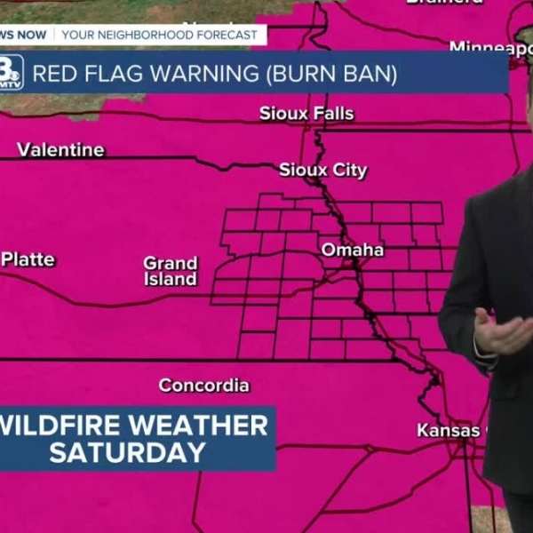
High wildfire risk over the next few days
Cool Friday, warming into the weekend
Wetter pattern expected next week
The National Weather Service has issued Red Flag Warnings for Omaha and surrounding areas this weekend. Wildfire danger is expected to reach high to extreme levels, especially on Saturday. Emergency officials are urging residents not to burn under any circumstances.
FORECAST
It will be a chilly evening with lighter winds compared to earlier in the day. Overnight lows will drop into the mid-20s, with some patchy frost possible by morning.
Saturday will be warmer but very windy, with southerly gusts reaching 35 to 40 mph and highs in the low to mid-60s.
Sunday will be much warmer and less windy, with highs climbing into the upper 70s.
The new week begins warm, with temperatures reaching the mid-80s on Monday.
A cold front is expected to arrive by Tuesday, bringing cooler temperatures in the 50s and 60s along with gusty winds. Rain chances remain low, and many areas may stay dry.
Wednesday and Thursday will be cloudier with calmer winds and highs in the mid-50s.
The best chance for rain arrives Friday, with showers possibly lingering into Saturday of Easter weekend. Easter Sunday is expected to be partly cloudy and mostly dry, with highs in the mid-50s.
FRIDAY NIGHT
Partly cloudy
Chilly
Low: 26
Wind: N 15–20 mph
SATURDAY
Mostly sunny
Windy
High: 65
Wind: S 25–40 mph


Leave a Comment