TEXAS — A more organized and potentially dangerous severe weather setup is expected to develop on Sunday, April 12, as conditions align across the central and southern Plains for strong to severe thunderstorms, including possible tornadoes.
Forecast data suggests this system could become one of the more significant severe weather events in the emerging mid-April pattern.
Low-pressure system draws Gulf moisture north
A developing low-pressure system near the Nebraska Sand Hills will drive this event by:
- Pulling warm, humid air from the Gulf of Mexico northward
- Increasing atmospheric instability across Texas, Oklahoma, Kansas, and Nebraska
- Creating a volatile environment favorable for strong storm development
This influx of moisture will fuel thunderstorms, particularly during the afternoon and evening hours.
Dryline and cold front to spark storms
A dryline and advancing cold front will play a key role by:
- Separating dry air to the west from humid air to the east
- Acting as the main trigger for storm development Sunday afternoon
- Focusing storms from central Texas through Oklahoma into Kansas
Storms forming along this boundary are expected to intensify rapidly in the unstable conditions.
Supercells may develop
Changing wind patterns with height, known as wind shear, will influence storm behavior:
- Some storms could evolve into rotating supercells
- These storms are capable of producing more intense and long-lasting severe weather
- The threat zone may extend from central Texas into Kansas and possibly Nebraska
This setup points to organized severe weather beyond typical thunderstorms.
Main threats: wind, hail, tornadoes
The primary hazards include:
- Damaging wind gusts that could cause structural damage and power outages
- Large hail, potentially significant in stronger storms
- A few tornadoes, especially with sustained supercell activity
Forecast models indicate at least a couple of tornadoes are possible where storm rotation strengthens.
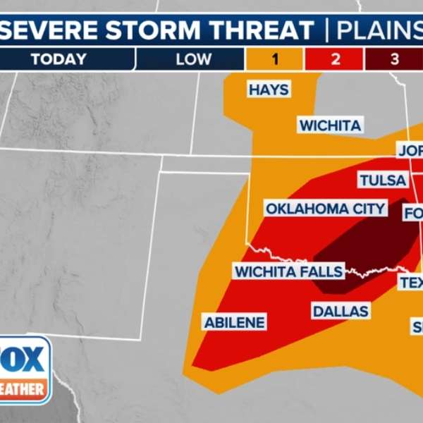
Risk area may grow
The Storm Prediction Center has issued a Level 2 (Slight Risk) for severe weather across parts of:
- Texas
- Oklahoma
- Kansas
- Nebraska, particularly central areas
This risk area could expand or intensify as confidence increases closer to the event.
Central Plains in focus
The highest concentration of severe weather is expected across the southern and central Plains, including:
- Dallas–Fort Worth
- Oklahoma City
- Wichita
These locations sit along the corridor where moisture, instability, and storm triggers are most aligned.
Forecast still evolving
While confidence is increasing:
- Exact timing and storm placement will become clearer in the coming days
- Small shifts could change which areas see the greatest impact
- Additional updates are expected as forecast models refine details
Residents across the Plains are encouraged to review severe weather safety plans, as Sunday’s setup could bring multiple hazards across a wide region.


Leave a Comment