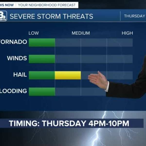
Several rounds of storms are expected to move through the region starting Thursday, with the potential for hail south of Omaha by Thursday evening.
Rain with pockets of hail Thursday
Drier conditions Friday
Multiple storm rounds expected this weekend
FORECAST
A cold front will continue moving through the region this evening. Spotty rain showers are possible near the Nebraska-Kansas border tonight, while most areas remain dry, less windy, and cooler, with overnight temperatures in the 40s.
As the front stalls along the Nebraska-Kansas border, several rounds of storms may develop Thursday, beginning later in the morning. Some storms could produce hail during the afternoon and evening, with the highest chances south of Omaha and Interstate 80.
Rain will gradually move out Thursday night, leading to drier and partly sunny conditions Friday, with highs near 60.
Storm activity returns over the weekend, with intermittent rounds expected from Saturday morning through Sunday evening. Some storms could turn strong to severe, especially on Sunday, bringing the potential for multiple weather hazards. Breezy conditions are expected, with highs in the 60s Saturday and the 70s Sunday.
Rainfall totals are estimated between 0.50 and 1.00 inches through Sunday night.
Temperatures will climb above average early next week, reaching the 80s on Monday before another round of storms arrives Tuesday, cooling temperatures back into the 60s by midweek.
WEDNESDAY NIGHT
Mostly cloudy
Less windy
Low: 41
Wind: N 10–15
THURSDAY
Cloudy
Rain and storms
High: 61
Wind: E 10–15
FRIDAY
Partly sunny
Drier
High: 60
Wind: NE 10–15


Leave a Comment