
As the weekend draws to a close, residents of the Mid-South brace for a potentially dangerous weather event. A fast-moving storm line is set to sweep through Tennessee, Arkansas, and Missouri, bringing with it severe thunderstorms and the alarming possibility of tornadoes. Meteorologists from the National Weather Service (NWS) have issued alerts indicating that these storms could deliver damaging winds of up to 70 mph, along with the risk of brief, spin-up tornadoes. As the storm front approaches, local authorities are urging citizens to take immediate precautionary measures.
Background
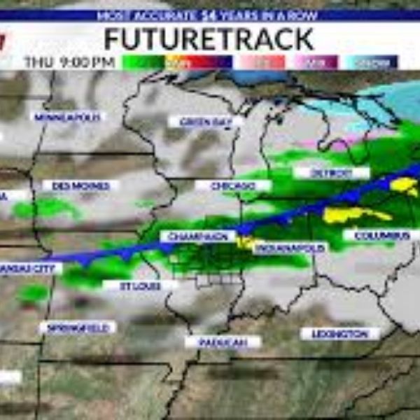
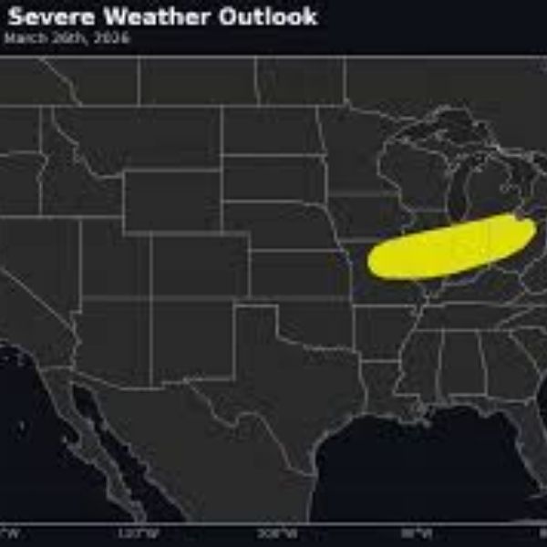
On March 13, 2026, the National Weather Service issued an Enhanced Risk (level 3 of 5) forecast for severe weather across parts of west Tennessee, northeast Arkansas, and southeast Missouri. This alert is particularly crucial for major cities such as Memphis, Jonesboro, Blytheville, Dyersburg, and Poplar Bluff, which lie directly in the path of the impending storm system. The forecast suggests a significant threat of damaging winds, power outages, and hazardous travel conditions as the storm line progresses across the region.
The fast movement of this storm system heightens the risk of unexpected weather changes, making it essential for residents to stay informed and prepared. With the potential for wind gusts between 60 to 70 mph, officials warn that these storms could cause widespread damage, including downed trees and power lines. Local interstates such as I-40, I-55, and I-555 could also experience treacherous driving conditions as the storm approaches.
Understanding the Weather Threat
The current weather models indicate that the line of storms will move rapidly from west to east across the Mississippi River Valley. Understanding the different types of weather threats associated with this storm is crucial for residents preparing for the worst.
Severe Thunderstorms
Severe thunderstorms are defined by their ability to produce damaging winds, hail, and heavy rain. In this case, the primary concern is the damaging straight-line winds that can arise from the storm system. Meteorologists expect wind gusts to reach upwards of 70 mph, which is strong enough to uproot trees, cause structural damage, and lead to flying debris.
Potential Tornado Formation
The NWS cautions that the storm system carries the risk of producing brief, isolated tornadoes. These tornadoes can develop quickly, often with little warning, making it essential for residents to stay alert and prepared to take action if necessary. The storm’s dynamics, combined with the warm, moist air prevalent in the region, create an environment conducive to tornado formation.
Rainfall and Flooding Risks
While the storm is expected to bring significant rainfall, forecasters predict that totals will be limited to around one inch. Due to the rapid movement of the storm, widespread flash flooding is not anticipated. However, localized flooding could occur in low-lying areas or regions with poor drainage, particularly if heavy rain coincides with existing conditions.
Preparedness and Safety Measures
With the storm rapidly approaching, local authorities and meteorologists stress the importance of preparedness. Here are critical steps residents should take to ensure their safety:
- Secure Outdoor Items: Residents should secure or bring inside any loose outdoor objects that could become projectiles in high winds.
- Prepare Emergency Kits: Ensure that emergency kits are stocked with essential items, including water, non-perishable food, medications, and first-aid supplies.
- Charge Devices: Charge cell phones and other electronic devices to ensure communication capabilities during power outages.
- Review Safety Plans: Familiarize yourself with tornado safety plans, identifying the safest location in your home to take shelter.
- Stay Informed: Keep abreast of weather updates from reliable sources, including the National Weather Service and local news outlets.
Impacts on Transportation
As the storm line moves through the Mid-South, travelers should be cautious and prepared for hazardous driving conditions. The high winds and potential for falling debris could make travel on major interstates particularly dangerous. Here’s what travelers need to know:
Interstate Conditions
The storm’s impact on major interstates, including I-40, I-55, and I-555, is a growing concern. Officials warn that winds could lead to difficult driving conditions, especially for high-profile vehicles. Motorists are advised to stay off the roads if severe weather warnings are in effect.
Air Travel Disruptions
In addition to ground travel, airports in the affected regions may also experience delays or cancellations due to severe weather. Travelers should check with airlines for the latest updates and be prepared for potential disruptions.
Analysis of Weather Patterns
The severe weather expected on Sunday is indicative of broader weather patterns that have become increasingly common in the Mid-South during this time of year. Climate change has contributed to more frequent and intense weather events across the United States, leading to heightened risks of severe thunderstorms and tornadoes.
Historical data shows that March is typically a volatile month for weather in the region, but recent years have seen an uptick in severe weather events. This pattern raises concerns about preparedness and the effectiveness of emergency response systems. Local governments and communities are encouraged to take proactive measures to enhance their readiness for such occurrences.
Conclusion
The weather alert for the Mid-South serves as a sobering reminder of nature’s unpredictability and the importance of preparedness. As residents of Tennessee, Arkansas, and Missouri brace for the impending storm, it is crucial to prioritize safety and stay informed. With the potential for damaging winds and tornadoes, taking precautionary actions can help mitigate risks and protect lives.
As the storm approaches, local communities must come together to support one another, ensuring that vulnerable populations are informed and equipped to handle the severe weather. The coming hours will be critical, and vigilance is paramount.
Frequently Asked Questions
What should I do if a tornado warning is issued?
If a tornado warning is issued, seek shelter immediately in a sturdy building. Move to a small, windowless interior room such as a bathroom or closet and protect your head and neck.
How can I prepare my home for severe storms?
Secure or bring in outdoor furniture, check the roof for loose shingles, and ensure that windows and doors are properly closed and secured.
What are the signs of an approaching tornado?
Signs of an approaching tornado include a loud roaring sound, a visible rotating cloud base, and debris being lifted into the air. If you notice these signs, seek shelter immediately.
How can I stay updated on weather alerts?
Stay updated by following reliable weather sources, such as the National Weather Service and local news stations. Consider subscribing to text alerts for real-time updates.
What items should be included in an emergency kit?
An emergency kit should include water, non-perishable food, a flashlight, batteries, a first aid kit, medications, and important documents. Don’t forget supplies for pets if necessary.


Leave a Comment