
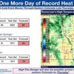
LINCOLN, Neb. (KOLN) – A combination of hot temperatures, low humidity, and gusty winds will create critical fire weather conditions across much of the area today. A Red Flag Warning is in effect for nearly all of central and western Nebraska, extending into Thursday morning for parts of north central and western regions.
This afternoon is expected to bring near-record or record-breaking heat, with highs ranging from the mid-80s to mid-90s. In Lincoln, temperatures are forecast to reach around 90 degrees, just shy of the record high of 91 set in 1907.
What You Need to Know
Today: Expect mostly sunny skies, hot temperatures, and breezy conditions with west to northwest winds of 10 to 20 mph and gusts up to 30 mph. The mix of heat, low humidity, and wind will create critical fire weather conditions across much of Nebraska and parts of north central Kansas. Skies will turn mostly clear to partly cloudy overnight.
Thursday: Cooler and windy conditions arrive as a cold front moves through the region. North winds will increase to 20 to 30 mph, with gusts reaching up to 45 mph. There is a slight chance of rain in the afternoon. High temperatures will vary widely, from the upper 40s to mid-80s depending on when the front passes.
Thursday night into Friday: Breezy conditions will persist with north winds of 15 to 25 mph and gusts up to 35 mph. There is a slight chance of rain, with the possibility of some snow mixing in before precipitation ends. Friday will be mostly sunny but much cooler, with highs in the upper 40s to upper 50s.
Weekend Outlook and Beyond
A warming trend begins Saturday, with highs in the low 60s to mid-70s and breezy conditions. Sunday will turn even warmer, with temperatures reaching the upper 70s to upper 80s. Early next week looks warm again, with near-record highs and a slight chance of rain.


Leave a Comment