
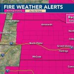
Extreme fire conditions are expected to peak Saturday, with winds up to 45 mph and humidity dropping as low as 8–15% statewide.
LINCOLN, Neb. (KOLN) — Red Flag Warnings are in effect across Nebraska as dangerous fire conditions develop heading into the weekend, combined with unseasonably warm temperatures and strong winds that could rapidly spread fires.
Saturday: Extreme fire danger
Saturday will bring the most critical fire weather of the period, with Red Flag Warnings covering the entire state. Relative humidity is expected to drop to 8–15%, creating extremely dry conditions that allow fires to spread quickly.
Strong southerly winds will be the main concern, sustained at 20 to 30 mph with gusts reaching 40 to 50 mph. This combination of wind and dryness creates a high risk for rapid fire growth.
Temperatures will rise into the 60s and low 70s — warmer in western areas — though the primary threat remains the wind and low humidity. Relative humidity is expected to fall below 30% as early as 9 a.m. when the warning begins.
Skies will remain mostly sunny with occasional passing clouds, offering no relief from the fire threat.
Sunday: High fire danger continues
Fire danger will remain high to very high on Sunday as an upper ridge moves over the region. Temperatures will climb into the upper 70s and 80s.
Winds will ease slightly, with gusts up to 20 mph, providing some relief, but fire conditions will still be elevated.
Monday: Record heat possible
Monday is expected to be the warmest day of the stretch, with highs in the mid- to upper-80s and low 90s. Several areas could approach or break record temperatures. In Lincoln, a forecast high of 88 degrees would tie a record set in 1917.
Pattern change ahead
A cold front is expected to move through Tuesday morning, bringing cooler and cloudier conditions. High temperatures will drop into the 50s and 60s — a sharp decline of more than 30 degrees from Monday.
Winds will shift to the north and remain gusty.
Rain chances will increase through midweek, with low chances for light precipitation from Tuesday through Thursday. A mix of rain and snow is possible at times, though no winter impacts are expected. Better chances for precipitation are forecast Wednesday night and Friday night as a broader weather pattern change develops.
Overall, warm and dry conditions will dominate through the weekend and early next week before cooler, wetter weather returns.


Leave a Comment