KENTUCKY — A dramatic weather shift is unfolding across Kentucky, Tennessee, Indiana, and Ohio, where residents are preparing for a sharp temperature drop and bitter wind chills before a rapid warm-up pushes highs close to 80 degrees by the end of the week.
Forecasters say the region will experience one of the most extreme temperature swings of the season, shifting from near-winter conditions to springlike warmth within just a few days.
Bitter cold follows early-week storms
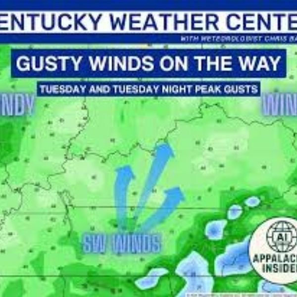
After early-week storms brought rain and severe weather, a strong cold air mass is sweeping into the region. From Monday afternoon into Tuesday, temperatures are expected to drop significantly, with wind chills falling into the 5 to 15 degree range across multiple states.
This cold snap will feel especially harsh after recent mild conditions, creating a sharp contrast that could catch residents off guard. Northern areas, particularly in Indiana and Ohio, may experience the coldest conditions, while Kentucky and Tennessee will also see a significant chill.
Meteorologists warn that gusty winds will intensify the cold, increasing the risk of discomfort and exposure for those spending extended time outdoors.
Rapid warm-up by midweek
Despite the cold start, conditions will change quickly as warmer air moves into the region. By midweek, temperatures will steadily rise, setting up a dramatic turnaround.
Forecasters note that such rapid rebounds are typical during the transition from winter to spring, though the scale of this swing stands out. Each day will feel noticeably warmer than the last.
Highs near 80 degrees by Friday
By Friday, temperatures across Kentucky, Tennessee, Indiana, and Ohio are expected to reach the mid to upper 70s, with some areas nearing 80 degrees. This marks a complete reversal from early-week conditions, bringing a late-spring feel.
The official start of spring also arrives Friday morning, aligning with the warmer pattern. However, the clash between warm and cool air could increase the chances of additional storm systems.
Seasonal shift brings volatility
Meteorologists describe this pattern as a classic example of springtime volatility, where rapid weather changes are common. Still, the intensity of this swing—from wind chills near 5 degrees to temperatures close to 80—makes it particularly notable.
Such fluctuations can impact energy demand and increase the risk of early-season severe weather as warmth returns.
Prepare for rapid changes
With conditions shifting quickly, officials urge residents to prepare for both cold and warm weather. Layered clothing, heating precautions, and staying updated on forecasts will be important early in the week.
Later in the week, residents can enjoy warmer conditions while remaining alert for any developing storms tied to the warming trend.


Leave a Comment